

Sept 13, 2010…Harrison to ridge to ‘Miracle Mountain’…Tr #217…
hike # 370 by Betsy
This is a very long and very hard hike and our fourth time to the plane crash site…the first being our unsuccessful search for it; this is the hike wanted to do last week but turned back due to the fog. Skies were mostly cloudy when we left home today but headed up Pack River Rd anyway. Surprisingly there was one rig at the trail head, and we met the couple coming down…they had stayed the night up at the lake. We saw no one else today.


Here is what happened: With the top of the mountain covered in cap clouds, the Cessna 172, C-70040 hit a large snag 10' from the top and it split the plane in half. The two less injured walked out to Priest Lake….unbelievable…and the two more seriously hurt stayed with the plane and made a fire. Turns out they all should have stayed with the plane because their beeper had been picked up and the wreckage was located for the search party. But they didn't know that. Eventually most of the fuselage was removed but a tail section was hanging by a cable and could not be accessed so it is still there, but now lying below amid the boulders. The NTSB attributed the crash to pilot error, with misjudgment, clouds, mountains and a mountain wave being contributing factors.
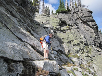
Four years ago, in September 2006, for the Irwin family, we encased the article in a plastic sleeve and fixed it securely to the tree. Today, the sign was still okay but the article was gone. The straps which were holding the article are still attached to the tree. I hate to think someone would steal it but there was no trace of it or any part of it lying around. Nothing…no plastic pieces, no paper. So sad. I don’t think it was a bear. Took more pics of the main part of the wreckage still lying down in the boulders below and then sat down to eat lunch while enjoying the view. For the walk back to the only way down off the ridge, we decided to not go thru the boulders but instead to use the ridge route down Sister #6. It was SO much easier and faster! Added to the knowledge base! Climbing down the steep granite wall went well…again, I found an easier way to get down than the way Jim did. I kept holding my breathe while watching him and thought...I am NOT going that way. The drop off was straight down as in straight down! Once down to the granite, as usual, we got “misguided” but the new GPS saved us. It told us we were way off track and we then knew which direction to turn so we didn’t get lost as badly as usual. Finally, we got down the last rock wall, back across the river and then bushwhacked up to the main trail down the rough descent. When we got to the truck, I recorded that I was so tired, my feet hurt, my knees hurt, the bottoms of my feet were burning and I was ready to go home to “the boys.” A good hike but a long day.

Left home 8:20
Started up 9:30Got up to ridge 1:25
Started back 1:40
Got back to main trail 3:30
Got to truck 4:35
Total miles hiked 11 miles
Total hiking time 7 hours, 5 minutes
GPS readings N48.40.073 W116.39.974 (location of wreck)
No comments:
Post a Comment