

Jul 5, 2010…Strong Creek…tr#444 …hike # 360…
***7th Anniversary of hiking!
by Betsy
The plan was to go up into the Selkirk’s and go off trail to Little Harrison Lake via Harrison Lake. While trying to decide on an alternate hike, just in case of rain, I went thru the old hike reports and thought of this hike out of Hope, and a hard, long and steep hike it is. We’ve hiked this one five times before, a lot on snowshoes and once continuing on to the top of Round Top Mt. That was hard. When the weather report for today sounded ominous, 30% chance of rain, thunder and lightning, it was either this or 12 mile Gold Hill. With the grey overcast skies, we dressed accordingly in long pants.


Wildflowers abounded with Queen’s Cup taking predominance. Lots of Wild Roses, yellow violets and Indian Paintbrush and as is so typical of this trail, the Brain Coral Mushroom. We didn’t see even one Fairly Slipper, the rare and small wild orchid…I thought for sure we would see some in the damp and boggy soil at the beginning.


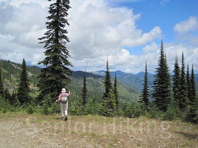
Now the trail began to get steep and we so regretted wearing long pants and longed for the shorts. Jim finally zipped off his pant legs; I just rolled up the bottoms. The views were beginning to become outstanding. Working our way over and under the jagged Cabinet Mountain shale, we began switch backing across the 2200’ vertical feet to the saddle.

The old Auxor Mine at 5006’ is about 2½ hours up. The entrance inside is now blocked with a strong gate to discouraged idiots from venturing too close to the edge of the deep dark hole! In addition to the gate, so much work has been done on the trail since we have been there…don’t know if it was the U.S. Forest Service who did it but all the drainage issues were also addressed very well.
As we got closer to the top, we could see black clouds filled with “weather” closing in around us and the sound of thunder alerted us to possible wind and rain. I was beginning to get hungry and we debated whether to stop where we were to eat and turn around or eat and decide whether or not to continue. Being so close to the top, we just kept going, taking whatever the weather gods had to dump on us. Looking over across the lake at Gold Hill we were so glad we didn’t climb that…the rain was pouring down heavily over there.

Finally up at the top at 5700’, we found a sheltered spot in the sun to get out of the wind and cold…I put my jacket on and changed my socks on for the trek down. Getting down seemed to take forever; I was in the lead and boogieing fast, carefully avoiding tripping on the jagged rocks. I had to stop a couple of times to adjust my socks in the left boot…it was killing my arch and I’m sure it had to do with the steepness. We saw very few tracks, but one elk track imbedded in the mud stood out very well.
Left home 9:00
Started up 9:40
Got to top 1:15 (3 hours, 35 minutes)
Started down 1:40
Got to truck 4:15 (2 hours, 35 minutes)
Total miles hiked 16 miles
Total hiking time 6 hours, 30 minutes
Elevation gain 3600’ ???
No comments:
Post a Comment