Oh to retire! A very scary thought. My husband is going to retire this year...in a week in fact. So how is this scary? I am not sure if it is scary for him but for me, it means the possibility of a variety of changes. Some of these are exciting but some are down right frightening.
My husband and I have raised 5 kids and have 24 grand kids. Our youngest has been out of the house for several years now. Life changed when she left home. We became "Empty Nesters". That was a very difficult time for me. I had been the "mother" for close to 30 years. For the most part, I was an "at home" mom. I actually did have a job just prior to her leaving and that helped keep my days somewhat busy but the evenings, wow, how quiet our home became without her constant chatter.
Things filled up those empty spaces that the children had previously occupied. One main thing, my husband moved his parents to our home so that we could take care of them. They both had Parkinson's Disease. His dad had the paralyzing kind and was unable to even turn over in bed. I quit my job and took care of them full time. They both passed away within a little over 2 years (those were wonderful years - taking care of parents was quite rewarding for us).
Just when I felt that our time would be lonely again, our oldest grandchildren came to live with us for a few months. That did help with the transition from "total parent care" to "back to motherhood". After the grandchildren left, we became empty nesters again. I filled my days with doing lots of genealogy and spending time with the grand kids. Last year my daughter and I began the vinyl business and that filled the little empty spaces of time. I also love dogs and we have had a few dogs as my "babies" to mother.
I actually have lots of hobbies and "things" with which to entertain myself. My days fly by. I have very little time to feel bored or lonely. My husband, on the other hand, has no hobbies. This is the biggest reason that I am dreading retirement. I have my routine. It allows me the freedom to do my day as I please. I entertain myself in genealogy, house cleaning, traveling to see family, computer, and vinyl work. If I feel like taking a hike to the beach (on our property), I do. If I want to read a book or even watch TV... I do! I don't have to make arrangements with anyone. I don't have to schedule my day with anyone....I just do what I want to do.
Weekends are different. When my husband is home, it seems that the days revolve around what he wants to do (to be fair, he doesn't ask me to do this, I just feel the need to be available to do what he wants if he has plans). Over the years I have adjusted to this fact. I don't mind what we do on the weekends but I look forward to Monday so I can have my week back to myself. Now with retirement, I have this feeling that it will all change. As I said, my husband has no hobbies. What will he do to occupy HIS time? I think he will expect his days to be like the weekends. If so, where is MY time? I know he has been looking forward to this day. He thinks he will have so much to do that he will always be busy. I hope so but there are days on the weekends that we don't have plans. Those days are torturous as he mopes around and gets frustrated because he's so bored. I have this fear that we are going to have way too many of those boring days. I don't know about most households but in ours, if Daddy is unhappy, the whole household feels it. Even if I retire to the office (to MY space), I can feel the stress building within the walls and soon, my day is spent trying to find ways to make his day better.
I do look forward to some time to travel. The problem I see with this is that in the past, he has never been the greatest traveler. He likes his home. He thinks that will change now that he won't have to rush back to a job. I hope so. He is pretty tight when it comes to money though. I wonder how many nights we will sleep in the car because he wants to keep going to our final destination and he won't want to stop and waste money on a motel - hmmmm! Speaking of that, I would love to stop at some interesting sites along the way and in the past, he has just wanted to go "not stop until we've reached where we planned to go". I wonder if we will be able to compromise?
People seem to look forward to retirement. Mostly for the fun, relaxation, travel, visiting, and togetherness that they can experience. It has been so many years of him going off to work and me having the days to myself, that this time is quite frightening to me but maybe I should look at it differently....look at it as an adventure. I know the future will be different...and a huge adjustment. I know with a lot of patience, we both will make it. As I write this, I am actually starting to get excited. Maybe it's time for change...maybe it's time for me to expand and get on with this new life...maybe retirement is going to be fun....maybe!

Monday, October 4, 2010
Sunday, October 3, 2010
Senior Hiking #370 - Miracle Mountain
I am sorry to be so slow at getting these posted. I have been busy with teaching genealogy classes, setting up a new blog for the classes, and doing orders for my vinyl company. Betsy is so good about sending me her hikes and I am thrilled with the beautiful pictures she shares with us. I will try to do better at my part and hope you are enjoying these wonderful hikes. (by Diane)
 51° - 61°
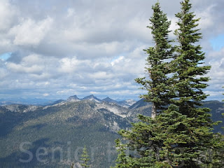
Sept 13, 2010…Harrison to ridge to ‘Miracle Mountain’…Tr #217…
hike # 370 by Betsy
This is a very long and very hard hike and our fourth time to the plane crash site…the first being our unsuccessful search for it; this is the hike wanted to do last week but turned back due to the fog. Skies were mostly cloudy when we left home today but headed up Pack River Rd anyway. Surprisingly there was one rig at the trail head, and we met the couple coming down…they had stayed the night up at the lake. We saw no one else today.
 So once again, using the Harrison lake trail as a jumping off point for more adventure, we cut off trail just before the lake and bushwhacked down to the river, crossed it and climbed up the steep rock wall. We could probably do it with our eyes closed by now…so many hikes over this way. Crossing the granite for a short bit, we headed up the steep wall of granite and boulders. New cairns marked our way. If you don’t know where you’re going it is very easy to not only get lost but get disorientated, which we always seem to do on the way back! Up and over boulders and granite we went, always looking up toward the ridge to see if we can find the tree with the sign.
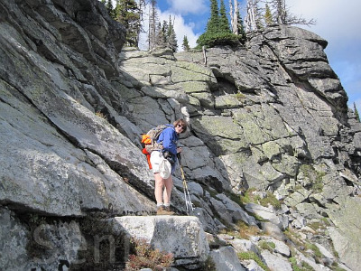
 Finally realizing we were not far enough up yet, we decided to look for the only possible way up to the top. We have come down this chute in the past. It is about as close to rock climbing as you can get without using ropes. If our report reading group could have seen us, their eyes would have widened in amazement, as my own do quite frequently as well! Pictures help but just never really tell the story. We slowly worked our way up the narrow and almost vertical wall of rock, each one keeping an eye on the other. Whew…we did it. I tried not to look down.

 Up now on the ridge we headed over and behind the huge “Sister #6” mountain in the Seven Sisters Range. Traversing across four difficult boulder fields, I finally let out a loud yell saying I could see the tree and the sign, and also some of the wreckage which is still left on our side of the ridge, about 30’ below…here is where the windshield, wing and other smaller pieces landed. After walking around and taking some more pics of the wreckage, we walked up to the ridge to check the sign and look below the other side of the ridge at the wreckage 150’ below down in the boulder field. We had fixed the broken bolt on the old sign in the past and added the article that I able to find in the 1986 Daily Bee about the two couples in the plane…a mom and dad and their son and daughter-in-law…and the crash itself, and how they survived on the crash on that Sunday, April 20, 1986, as they were returning home to Bonners Ferry. Long time report readers will remember this story.
 Being a genealogist, I know that all back issues of the Bonner County Daily Bee are stored at the Historical Society Museum and after reading the account, and knowing the exact spot and the conditions possible in April with snow and wind, it is exactly as what the sign says…a miracle! Had they crashed into Sister #6, they would not have survived.
Here is what happened: With the top of the mountain covered in cap clouds, the Cessna 172, C-70040 hit a large snag 10' from the top and it split the plane in half. The two less injured walked out to Priest Lake….unbelievable…and the two more seriously hurt stayed with the plane and made a fire. Turns out they all should have stayed with the plane because their beeper had been picked up and the wreckage was located for the search party. But they didn't know that. Eventually most of the fuselage was removed but a tail section was hanging by a cable and could not be accessed so it is still there, but now lying below amid the boulders. The NTSB attributed the crash to pilot error, with misjudgment, clouds, mountains and a mountain wave being contributing factors.


Got up to ridge 1:25
Started back 1:40
Got back to main trail 3:30
Got to truck 4:35
Total miles hiked 11 miles
Total hiking time 7 hours, 5 minutes
GPS readings N48.40.073 W116.39.974 (location of wreck)

Sept 13, 2010…Harrison to ridge to ‘Miracle Mountain’…Tr #217…
hike # 370 by Betsy
This is a very long and very hard hike and our fourth time to the plane crash site…the first being our unsuccessful search for it; this is the hike wanted to do last week but turned back due to the fog. Skies were mostly cloudy when we left home today but headed up Pack River Rd anyway. Surprisingly there was one rig at the trail head, and we met the couple coming down…they had stayed the night up at the lake. We saw no one else today.


Here is what happened: With the top of the mountain covered in cap clouds, the Cessna 172, C-70040 hit a large snag 10' from the top and it split the plane in half. The two less injured walked out to Priest Lake….unbelievable…and the two more seriously hurt stayed with the plane and made a fire. Turns out they all should have stayed with the plane because their beeper had been picked up and the wreckage was located for the search party. But they didn't know that. Eventually most of the fuselage was removed but a tail section was hanging by a cable and could not be accessed so it is still there, but now lying below amid the boulders. The NTSB attributed the crash to pilot error, with misjudgment, clouds, mountains and a mountain wave being contributing factors.
Four years ago, in September 2006, for the Irwin family, we encased the article in a plastic sleeve and fixed it securely to the tree. Today, the sign was still okay but the article was gone. The straps which were holding the article are still attached to the tree. I hate to think someone would steal it but there was no trace of it or any part of it lying around. Nothing…no plastic pieces, no paper. So sad. I don’t think it was a bear. Took more pics of the main part of the wreckage still lying down in the boulders below and then sat down to eat lunch while enjoying the view. For the walk back to the only way down off the ridge, we decided to not go thru the boulders but instead to use the ridge route down Sister #6. It was SO much easier and faster! Added to the knowledge base! Climbing down the steep granite wall went well…again, I found an easier way to get down than the way Jim did. I kept holding my breathe while watching him and thought...I am NOT going that way. The drop off was straight down as in straight down! Once down to the granite, as usual, we got “misguided” but the new GPS saved us. It told us we were way off track and we then knew which direction to turn so we didn’t get lost as badly as usual. Finally, we got down the last rock wall, back across the river and then bushwhacked up to the main trail down the rough descent. When we got to the truck, I recorded that I was so tired, my feet hurt, my knees hurt, the bottoms of my feet were burning and I was ready to go home to “the boys.” A good hike but a long day.

Left home 8:20
Started up 9:30Got up to ridge 1:25
Started back 1:40
Got back to main trail 3:30
Got to truck 4:35
Total miles hiked 11 miles
Total hiking time 7 hours, 5 minutes
GPS readings N48.40.073 W116.39.974 (location of wreck)
Thursday, September 30, 2010
New Website for Family History
I have been creating a new website for the Family History Center in Idaho. It is directed for the beginner but hopefully has something for everyone to learn how to search for their ancestors. Classes are given at the Sandpoint, Idaho Family History Center until the 20th of October. They cover the basics of doing genealogy and some basics of learning how to do things on your computer, the Roots Magic genealogy program, and searching the Internet for information about your ancestors.
Questions are encouraged - if you have a question about something, someone else most likely will have the same question. The email address is FHCsandpoint@gmail.com. To make things easier, the website is called http://www.fhcsandpoint.blogspot.com/.
There are a lot of links that you can click on to that will take you to a variety of websites to assist you in learning and finding the things you need.
Check out the site and please feel free to ask questions. Thanks!
Friday, September 24, 2010
Senior Hiking #369 = Harrison Lake Trail 217
42° - 51° Foggy

Sept 6, 2010…Harrison Lake…tr # 217…
hike # 369
by Betsy
The weather was supposed to be around 61° with partly cloudy skies…NOT! Instead we had very overcast sky with fog all around us which only got worse the closer we got to the trailhead. It was a bit on the chilly side…we wore long pants today and I put on my jacket, pulled up my socks, put my hood up and we both wore our ragg wool mitts. A few raindrops hit the windshield. My voice recorder didn’t seem to be working but it was…guess I need to read Joe Blow’s instructions. In order to not get shot at…it is now hunting season…we wrapped our orange vests around our packs.
 A short way up into the trail, we saw a blue jacket lying on the side of the trail…and met its owner a short time later as he came down. He had his ear buds in for tunes and his bear spray on his belt! He told us that the sun was out up at the lake...he lied! It was not. The fog only increased as we hiked and when we got to the spot to turn off trail, we decided against it due to the thick fog. The plan was to go to Harrison Lake and from there go over across the granite and up to the ridge to see the plane crash wreckage and the sign up above. But because we couldn’t see much in front of us much less the views, we nixed that idea and went straight to the lake, where we found ourselves completely fogged in. However, every thirty seconds, the fog would move around just enough for me to get a few nice shots.
 As we were eating lunch, a young couple walked into the lake…ready to take on the ridge as we were. After chatting a bit, we convinced them to walk up the steep boulder side at the end of the lake…they went for it. We have come down that way in the past. It was now 42°…and my hands were freezing even with heavy Ragg mittens. Out came the HotHands which we both carry year round. We tried to think of something else to do…the hike to the lake is just too short to turn around there. Since the views were non existent, we just walked down the connecting trail, the other and longer way into the lake from Bonners Ferry, and all the while the temperature kept dropping. Don’t you just love global warming??? Summer lasted about ten days this year.
 On the way down, I spotted a beautiful red mushroom...of course I had to photograph it. We got sprinkled on a bit just as we were getting to the end and came close to digging out the raingear but took a chance that we could make it out which we did. Driving home and back out in civilization, we saw a large bear crossing Upper Pack River Rd…but it was too fast for me and was gone before I even got the camera out. He was a big boy.
(Bears dig at logs to find ants)

Left home 8:30Started up 9:30
Turned around 1:30?
Got to truck 2:30
Total miles hiked 9 miles
Total hiking time 5 hours

Sept 6, 2010…Harrison Lake…tr # 217…
hike # 369
by Betsy
The weather was supposed to be around 61° with partly cloudy skies…NOT! Instead we had very overcast sky with fog all around us which only got worse the closer we got to the trailhead. It was a bit on the chilly side…we wore long pants today and I put on my jacket, pulled up my socks, put my hood up and we both wore our ragg wool mitts. A few raindrops hit the windshield. My voice recorder didn’t seem to be working but it was…guess I need to read Joe Blow’s instructions. In order to not get shot at…it is now hunting season…we wrapped our orange vests around our packs.


(Bears dig at logs to find ants)

Left home 8:30Started up 9:30
Turned around 1:30?
Got to truck 2:30
Total miles hiked 9 miles
Total hiking time 5 hours
Thursday, September 23, 2010
Diving with Sharks?
This last weekend I got to go babysit my grandchildren in Utah while my son and daughter-in-law went for their scuba diving certification. Well, I had a wonderful time with the grand kids but it was so interesting visiting the site where they go scuba diving.
 First, the site didn't look anything like a place where anyone would go scuba diving. I mean, what comes to my mind when someone says they are going scuba diving is a lake or ocean - right? Not in this case. This spot was in the middle of the desert area and the diving area was little more than three ponds. There is absolutely no way I could describe it as more than that. It was quite interesting though. The first pond was enclosed by some plastic cover only about 4 feet tall. I guess if you are under water, you don't need to have much height on top of the water. It just looked strange.
 The second and third ponds were connected by a tunnel. One had a covering over it and was the main hub for preparing gear and such. It was attached to a building which I can only assume was an office. The outside pond was the biggest yet it was not all that big. The interesting thing about these ponds was that they were all salt water spring fed. Because of that, they had some interesting fish in them...a shark, some stingrays, and several other kinds of fish.
The divers begin their training in a swimming pool then move to the plastic covered pond and finally get to swim with the sharks. I got to take the kids on the final day of their parent's dive.

 We watched them feed the shark and stingray right from the side of the pond. Some actually reached out and petted the shark. They fed the shark and other fish before anyone went in swimming. The hope was that the fish would be content and stay at the bottom of the pond while the divers did their diving. Sounds really scary to me but I wasn't in the water thank goodness.
The pictures are of the stingray being fed fish and the shark right near the edge close enough to touch.
What a fun experience I had this last weekend (other than the fact that I also ended up with the flu). I got to enjoy my wonderful grandchildren and visit this fun scuba diving place. Very interesting!
 First, the site didn't look anything like a place where anyone would go scuba diving. I mean, what comes to my mind when someone says they are going scuba diving is a lake or ocean - right? Not in this case. This spot was in the middle of the desert area and the diving area was little more than three ponds. There is absolutely no way I could describe it as more than that. It was quite interesting though. The first pond was enclosed by some plastic cover only about 4 feet tall. I guess if you are under water, you don't need to have much height on top of the water. It just looked strange.
The divers begin their training in a swimming pool then move to the plastic covered pond and finally get to swim with the sharks. I got to take the kids on the final day of their parent's dive.


The pictures are of the stingray being fed fish and the shark right near the edge close enough to touch.
What a fun experience I had this last weekend (other than the fact that I also ended up with the flu). I got to enjoy my wonderful grandchildren and visit this fun scuba diving place. Very interesting!
Wednesday, September 15, 2010
Senior Hiking #368 - Fault Lake Trail


Aug 30, 2010…Fault Lake Tr # 59…(15th time)
…hike # 368 by Betsy
All week the weatherman kept saying it was going to rain today but when we woke to partly cloudy skies, we decided to chance it to Fault Lake, normally a very hot, very exposed and always long hike. I love this hike in late August just because of the abundance of huckleberries, with their brilliantly red fall colors. I packed my new little digital voice recorder in my shorts pocket for taking notes.

There was no one at the trailhead nor did we meet anyone all day. Since it was quite chilly when we started out, I put my jacket on, with hood up and gloves on. We crossed the river over the rocks and logs without incident...real easy at this time of year…and began up. The sun was out and what started out as welcome warmth soon became a blast furnace, even at 58°. Not only due to the heat and starting out too fast up the steep slope, I soon succumbed to fatigue and overheating. My energy level dropped to the ground…now it was my turn to bonk. We traveled slowly with lots of rests in the shade…then we both ate a Gu-Gel for energy and this seemed to help. I had been running on low all week so I thought that had a lot to do with it. After 1½ hours at Gunsight Creek, Jim said that we could turn around and as inviting as this sounded, I pursued, thinking that I might turn around soon enough and that there was no way I was ever going to make it to the lake. The second part of this hike is well out and exposed in the hot open sun.


There were absolutely no huckleberries till we reached a high elevation and even those, while small, were not plentiful. These bushes were sheltered by hovering pines, offering protection from that early spring freeze. Higher up still, we found a handful of bushes that were quite laden and we feasted while thinking about the poor bears. Always watchful for bears up in the rocks, as per our record…we saw none! What was lacking in huckleberries was made up for in wildflowers…so much white Pearly Everlasting, pink Fireweed and red Indian Paintbrush, with a lot of yellow Tansy thrown in for good measure. After almost a long 3½ hours we reached the lake. Without sunshine, the water lacked the gorgeous blue green color. We moved to the end of the lake for lunch to get out of the wind which was picking up…and yes, it was jacket time again.


Jim decided not to dive in today as he did last year! Skies were turning black and we didn’t linger too long…plus we knew it was going to be a long hard hike down. We made it almost to the end before we got rained on, but not enough to dig out the raingear. Thunder could be heard toward the east over the Cabinet Mountains, and I thought I saw one bolt of lightning. Just as we were driving out, the rain came down quite a bit harder…made it out just in time.


Left home 8:15Started up 9:15
Got to lake 12:55 (3 hours, 25 minutes)
Started down 1:20
Got to truck 4:10 (2 hours, 50 minutes)
Total miles hiked 15 miles
Total hiking time 6 hours, 40 minutes
Saturday, September 4, 2010
Parmesan Ranch Chicken
I love this recipe but hadn't made it in a long time. Last night I made it for a family gathering in celebration of the life of our dear friend that passed away a week ago. It is so easy and extremely tasty. It makes your house smell so yummy while it's cooking too!
Parmesan Ranch Chicken
1 cup crushed Corn Flakes
1 cup Parmesan Cheese
1 package Ranch Dressing Mix (NOT the liquid)
18-20 Chicken Tenders (the strips)
1/2 cup Butter or Margarine melted
Mix all of the dry ingredients together into a low bowl or plate. Dip chicken into the butter then roll in dry mix. Spray cookie sheet with oil spray. Place coated chicken onto the cookie sheet and bake at 350 degrees for about 40 minutes (uncovered) or until done.
Subscribe to:
Posts (Atom)